
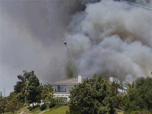
 A helicopter drops fire fighting material over a house as smoke envelopes the area in Carlsbad, Calif., in this May 14, 2014, file photo.
ORANGE, Calif. - Fire-hardened Southern Californians know that when the Santa Ana winds blow, a wildfire probably isn't very far behind - the only questions are where it will erupt and how bad it will be.
A new online mapping tool rolled out Wednesday by the U.S. Forest Service and San Diego Gas & Electric will help homeowners and emergency responders answer both those questions with a color-coded early warning system indicating which areas have the highest fire risk when the hot, dry wind blows.
The Santa Ana Wildfire Threat Index includes a six-day outlook and uses 30 years of historical weather data and information about how parched local vegetation currently is to rank danger in four zones from Santa Barbara to San Diego.
"We can see three, four, five days away, 'Is this going to be one of those garden variety Santa Ana wind events we have or is this really going to be devastating to a particular area?'" said Tom Rolinski, a U.S. Forest Service meteorologist.
When winds are gusting, the maps will be updated with yellow for marginal fire risk, orange for moderate, red for high and purple for extreme. Clicking on an area will yield a full forecast, as well as advisories about how to prepare for a possible conflagration. Users also can find the locations of fires already burning and live readings from weather stations.
Tips for those in the higher risk areas will include charging cell phones, keeping a full gas tank, studying evacuation routes and making contingency plans for pets.
"You live in the mountains and you work down in the city, what happens if a wild land fire breaks out in the middle of the day? How do you get to your pets or your kids in day care?" said John Miller, spokesman for the U.S. Forest Service.
The map is at www.santaanawildfirethreat.com.
Utilities can also use the tool to prepare for strong winds that could knock down power lines; fire agencies can deploy engines in advance; and local agencies will know when to postpone construction work that could start a fire.
The maps are only intended for use when the winds are blowing, Rolinski said.
They showed no fire risk during this week's record-breaking heat because there were no Santa Ana winds. A fire in Cleveland National Forest forced evacuations while another in the Northern California town of Weed damaged or destroyed 200 homes.
A beta version correctly predicted at least three fires in the past year, including devastating blazes in northern San Diego County during a wind event in May, Rolinski said.
Homeowners who live and work in the most fire-prone areas welcomed the idea.
It could ease concerns of potential homebuyers who are considering a purchase in a fire-prone area by giving the assurance of an early warning, Trisha Barry, a real estate agent, said as she took pictures of a wilderness hiking area on the fringe of northern Orange County suburbs.
The area is tucked between dense housing developments and scrub-covered foothills. Her photos were intended to help promote the home's proximity to the vast outdoor playground - but the location cuts both ways when it comes to wildfires, she said.
"I was here when there was a fire right on that hill and it was scary," Barry said, pointing across a dirt parking lot toward the mountains. "I think (the index) is a fantastic benefit to owners. It would be really helpful."